| • News & Status |
| • Info on Alternatives |
| • Quick Comparison |
| •• Road Widening |
| •• Rapid Transit |
| • About the Coalition |
| • E-mail your support |
| • Participate |
| • Related Links |
| • Alta Vista Corridor |
| • Sustainable Transport |
| • Health & Air Quality |
| • Organizations |
Updated
July 2, 2004
Info on Alternatives, Road Widening, Air Quality Impacts
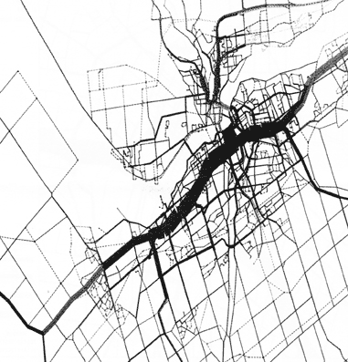 |
The map on the left is from the City of Ottawa's EMME/2 tool using 1995 traffic data. It shows the daily emissions per roadway for the Ottawa-Gatineau area. The volume of emissions on a road is represented by the thickness of the line. The Queensway is easily identified as the thickest line on the map (running roughly diagonally from the lower left to upper right). In Ottawa, most of our air pollution comes from vehicles because we have no heavy industry. As can be seen from this map. The Queensway is Ottawa's largest single daily source of both green house gases and pollution. For instance, the Queensway currently contributes roughly 16% of all the carbon monoxide emission for all roads for the region. By 2021 it is expected the Queensway 's share of carbon monoxide from roads could rise to 36%. |
Making the Queensway wider to accommodate more cars will result in more emissions. Does it make sense to take the region's biggest single source of air pollution and make it bigger?
Alternatively, lowering the speed limit on the Queensway between St. Laurent and Richmond would improve the functioning of the ramps, reduce severity of accidents and lower fuel consumption ... which would mean lower emissions (green house gases and pollution).