 |
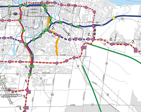
This map is a portion of the Rapid Transit Network map map from the Transportation Master Plan of the City of Ottawa's New Official Plan, with the Alta Vista Corridor highlighted in yellow. The two most important elements of the TMP's transit plan in the Alta Vista Corridor context are:
|
In the map above, the existing bus transitway is in solid blue lines, the existing O-train in in solid red. Proposed busway extension are in dashed blue and proposed light rail lines are in dashed red. Solid green lines denotes other abandoned railway corridors for longer term consideration.
The following is a summary of key points from a proposal put forth by David Jeanes, President of Transport 2000 at the Public Meeting in June 2002.
The needs for commuters in the south urban areas could be served by extended the existing O-train service south along the rail corridor which runs due south. Light rail can carry the equivalent of up to 7 lanes of expressway traffic in terms of people. This extension would move more people at lower cost than a roadway and would be the least damaging to the environment.
To better serve the hospital complex, a light line rail line could be run from Hurdman station on the transitway to the hospital campus. Hurdman station has the largest numbers of buses passing through it which go to and from all points in the city. This connection would provide substantially better access to the hospitals and unlike the roadway option would not worsen the parking problems around the hospital campus. In addition, this rail line could follow the path shown in the map above to link up with a corridor which runs east past Blackburn Hamlet into the southern area of Orleans. Most of the hospital employees live east and north of the complex (See Mike Lascelles article in the Press section for details).
These two light rail extensions combined with other planned light rail lines which would run out to the west (Kanata) and south (Barhaven) would offer a complementary service which could be linked efficiently where these lines cross.
This transit alternative would only use a small portion of the Alta Vista corridor at the northern end between Hurdman and hospital complex. The rest of the Alta Vista corridor would remain as park, greenspace and allotment gardens. As can be seen in the map, the Alta Vista neighbourhoods would be surrounded by high capacity transit lines enabling commuters to be efficiently transported without adding to traffic problems in the neighbourhoods and therefore most of the corridor could be left as park land.
See the City of Ottawa's new Official Plan, or the Transportation Master Plan or the complete map of the proposed Rapid Transit Network.
See the Contacts section of this site for more information about Citizens for Healthy Communities.
Additional information on light rail in general can be found in the Background section.