Alternatives
This page compares the pros and cons of the City's preferred road alternative and Citizens for Healthy Communities preferred transit alternatives.
The need is presumed to be primarily for commuters living in bedroom communities south and east of the airport to get to and from work in downtown (about 1800 person-trips per hour). A secondary need is to improve access to the Ottawa Hospital's General Campus on Smyth.
This Environmental Assessment (EA) was supposed to consider alternatives for the Alta Vista Corridor and recommend a preferred solution. Options which were supposed to be considered were a roadway, a roadway with transit and transit only, all of which were to be considered with alternate routes. All of these alternatives were supposed to be considered together taking into account public and technical input including air quality and health consequences.
The Public Advisory Committee (PAC), Technical Advisory Committee (TAC) and consultant filled out detailed ranking of priorities as part of the "concordance method" in 2003, which was supposed to be used to evaluate all the alternatives. City staff condoned and supported the consultant's evaluation including not voting a higher priority to transit-based mobility compared to road-based mobility as well as flawed analysis which claimed a road solution would yield less pollution than transit.
The City's Preference: a Roadway in the Corridor
Using the concordance method to compare alternatives, the consultant under the City's guidance scored a 4-lane road as the theoretical best solution to meet the need of 1800 commuters per hour from the southeast. The 4-lane road which they choose has the following theoretical attributes:
- 2-lanes for motor vehicles (including trucks),
- 2-lanes for high occupancy vehicles (HOV), (including buses),
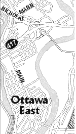
- runs from Conroy to Nicholas,
- intersections at Walkley, Kilborn, Pleasant Park, Smyth, Alta Vista and Riverside,
- interchange ramps added at the Queensway at Nicholas to allow access.
Since a roadway won the theoretical exercise, design is proceeding to see what can be built. In practice it is now clear that a 4-lane road from their concordance evaluation cannot meet one of the original need of 1800 person trips. For instance, the northern end will only carry 800 cars per hour at best in the morning. The 1000 person-trips per hour discrepancy is not a serious concern for the design team. City staff believe any road is better than transit and always better than nothing. City staff's unshakeable faith in car centric solutions is evident since they have no intention of going back to see how the road they are designing in practice would have scored in the concordance method or how the air quality will be as a result. The limitations of the road they are designing begs the questions: how hard, how much more cheaply (and how much more reliably in the case of light rail) could transit get 1800 people/hour from the Southeast to downtown? This EA has not answered those questions.
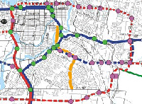
Maps and descriptions of the City's current proposed corridor roadway can be found by clicking on the link or maps below. These are the designs which shared with the PAC on April 22, 2005:
What's wrong with the way they chose their alternative?
- The alternative they are designing in practice doesn't match the capacity of the alternative that they claimed was the best solution in theory. As well, the HOV lanes have nowhere to go (The province has ruled out HOV lanes on the Queensway).
- They haven't accounted for induced traffic so their traffic increase estimates are too low for road expansion alternatives. From the APETIS report of 1999 we've seen errors in forecast traffic increases of as much as 50% when induced traffic is ignored.
- They have not done state-of-the-art air quality projections and associated health impacts.
- They have a double standard
and a bias with respect to cars versus transit:
- They didn't evaluate transit only options in the same way they evaluated road options as they were told to do by Transportation and Transit Committee.
- City staff condoned the consultant not giving more weight in their votes to transit compared to car based mobility in the "concordance" method .
- They investigated 27 combinations of road widenings outside the corridor but they said they could not look at transit alternatives outside the corridor. The message: if it's road based they're willing to explore it and if it's transit based they aren't.
What's wrong with their preferred alternative?
|
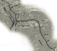
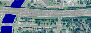
• A roadway will make traffic much worse on the Queenway, Nicholas, Lees, Riverside, Main and Alta Vista in the morning rush hour. The proposed corridor road will get traffic from the south to the traffic jam at the north end faster aggravating the northern bottlenecks. |
 |
Click here or on the image to see an expanded view and get more details. | |
|
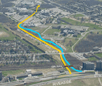
• A roadway will make air quality (pollution and green house gas emissions) worse. |
 |
Clogged roadways are very bad for air quality. More details. | |
|
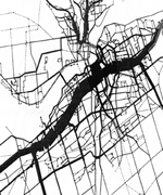
• A roadway will cost more than $135 million dollars (that is more than 4 times what it cost to put the O-train in service). |
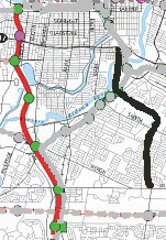 |
Existing O-train line on the left in red and proposed Alta Vista Corridor road on the right in black. More details. | |
|
• As of April 2004, the Ministry of Transportation of Ontario officially recognized that expanding the 417 in the downtown section from Metcalfe to Island Park is not feasible. The Queensway will not accommodate traffic from an Alta Vista Corridor road. |
 |
||
Citizens for Healthy Communities (CHC) Preference: Transit centric alternatives
There are two alternatives to consider: one for the short term for the hospital campus and another for the longer term for commuters from the south east.
In the short term:
 |
CHC want rapid transit access to the Ottawa Hospital's General Campus in place before road expansions. A 1.5 km bus spine road from the transitway into the hospital campus would provide more direct transit and emergency vehicle access. |
In the longer term:
 |
CHC want to see the rapid transit solutions serving the south and east sectors proposed in the city's Transportation Master Plan implemented before any decision on any major road expansion projects proceed. |
These transit alternatives would only use a small portion of the Alta Vista corridor. The rest of the Alta Vista corridor would remain as park, green-space, cycling paths and allotment gardens.
The city's transportation priorities are supposed to favour walking first, cycling second, transit third and single occupancy vehicles last. Cyclists and pedestrians can use transit. CHC wants to see the top priorities be treated as real priorities by getting most of the funding and getting the funding first.
Ottawa East
Alta
Vista Corridor
•AVC
Home
•News & Status
•Background
•Alternatives
•Contacts
•What
you can do
•Press
This page last updated on October 3, 2005