Background
• Maps
• History
• Light Rail Info
• Ottawa Specific Links
•
Other links of interests
 |
High level
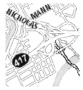
view showing the Alta Vista Corridor from Conroy & Walkley to
the Queensway & Nicholas interchange.
Click here or on the image to see an expanded view.
|
|
|
|
An animated map showing a roadway in the corridor and the most likely overflow routes for traffic in the morning rush hour highlighted in red. This map illustrates additional traffic in Ottawa East and Alta Vista which a roadway would introduce. Click here or on the image to see an expanded view. |
Click here for a summary of documents relating to the Alta Vista Corridor from 1990 to 2001.
The Alta Vista Transportation Corridor (also known in previous times as the Alta Vista Parkway or Expressway) is a project aimed at providing transportation relief for the south east sector of the city. The corridor begins at Conroy and Walkley and winds through green spaces and parks in Alta Vista (behind the Ottawa Hospital's General campus), through Hurdman Park, across the Rideau River to potentially terminate at the Queensway at the Nicholas ramp. The corridor has been part of the City of Ottawa Official Plan since 1974. When Highway 417 was being built, this corridor was one of the proposed routes (In fact, it was the first proposed route in 1965 as part of the "South East Freeway" which included plans to turn King Edward into an expressway through Sandy Hill and Lowertown). In 1994, an environmental assessment (EA) study was conducted to identify potential transportation demands to and from the southeast sector. This EA study served as the basis for the Transportation Master Plan of 1997.
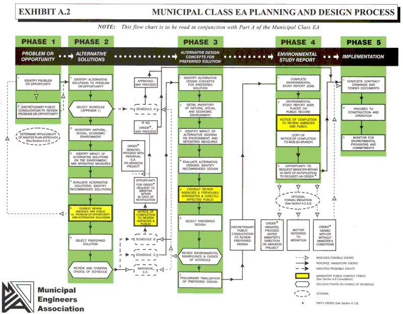
The city selected Delcan as contractor to do the environmental assessment for the Alta Vista Transportation Corridor. The assessment is supposed to review alternatives and recommend the "best" one. Selection of the contractor took place in the summer of 2001. Delcan is responsible to organize the public consultation for the City which began in the fall of 2001. Click here to see the process being followed.
Experience has taught us that there are some traffic planners who only think of highway building. Theirs is a world view forged in the 50's when more cars on the road was equated with progress. Over the years, two of their favourite tactics to get public opinion on side for building highways inside a city are to promise it will lower traffic on regular streets (even if in practice it never has) and to pit one neighbourhood against another. Reduced traffic on Alta Vista, Bank and Main has been claimed if this is a highway. The community associations in the downtown area are united against this claim because we've heard it before (most recently for the Bronson/Airport Parkway expansions) and we seen it to be false (see APETIS report for more details). Some of the folks in Alta Vista strongly want the corridor to be a highway because they want less traffic and so far they believe the story and don't realize it will have the opposite effect.
Nobody wants more traffic in their neighbourhood
Most of you reading this don't think we need more traffic on residential streets. The real question is: when has building a highway inside a city ever done anything but increase traffic in the neighbourhoods it traverses and how does this potential roadway project compare?
The big problem with this roadway if it is meant for automobile traffic is that the end point at the Nicholas on ramp of the Queensway is already saturated with traffic. There is no place for the traffic to go. The new highway will be backed up and clogged. This means drivers will take every opportunity to get off and cut around the traffic jam which will mean more traffic on Riverside, Alta Vista, Smyth, Bank, Main, Lees, Greenfield, King Edward and through the neighbourhoods.
The city's previous official plan was supposed to give priority, in order, to pedestrian, bicycle, mass transit and automobile traffic. It was also supposed to be doing something to reduce greenhouse gases. In practice, these things have yet to be done in anything other than a token basis. Green house gas emissions have risen 43% since 1996! The city's 2020 Summit in the was meant to kick off Smart Growth to plan for the next 20 years. Since the 2020 Summit, the city has increased road capacity while it has cut back on transit and either cut or delayed funds to cycling and pedestrian projects. This project is an opportunity for traffic planners to "walk the talk" for a change.
An Argument for Light Rail
(David Jeanes, President, Transport 2000)
Light Rail increases public transit use and reduces car use
- The propensity to use LR is 50% higher than a busway and almost double that of a typical bus system.
- LR offers a smooth, comfortable ride, and rail-to-rail or bus-to-rail transfer is less onerous than a bus-to-bus transfer. It is also accessible to wheelchairs, strollers and bicycles.
- A good example comes from Strasbourg where the opening of a single LR route increased overall transit patronage. Since 1990, transit patronage in Strasbourg has increased by 40% whilst the corresponding car traffic into the central area fell by 17%
Light Rail is environmentally friendly transit
- Electric LR has low noise and zero local emission and modem diesel LR also achieves very low engine noise and emissions.
- Each LR passenger has been credited with an improved energy efficient journey, compared to bus travel of around 40%, and former motorists attracted to public transit by LR reduces the overall energy demand even more.
Light Rail is the better economic option
- Cost per kilometre is as low as $2M for infrastructure, as per the 0-Train example. Bus transitways cost about $15M per kilometre. Roads cost even more.
- Extra road building and maintenance expenditure has higher hidden costs than rail.
- Hidden costs of cars include subsidized parking, health costs due to pollution, accident costs not covered by insurance, and police, fire and court costs.
Light Rail moves people efficiently
- Light Rail vehicles can form trains with hundreds of passengers per driver, and journey times are short and predictable.
- A single light rail track
can carry at least as much as a freeway lane (2200 people), and ultimately
this capacity can be increased 6 or 7 fold depending on the type of
alignment, headway and train length.
Light Rail integrates well into the urban landscape
- LR can share city streets, pedestrian malls and green spaces.
- LR can use existing rail lines, hydro corridors and roadway medians. Light Rail bridges, underpasses or tunnels will use less space than for roads.
- LR can cope with steep gradients and tight curves. It can run at reasonable speeds through narrow urban centres, with rapid and comfortable acceleration and braking.
- A light rail service can
have a major effect on land use developments around stations. Its permanence
increases passenger volumes, reduces car demands, and helps to reduce
sprawl.
Good rapid transit is complementary to walking and cycling (bicycles ride the O-train and on bus racks at no extra charge to their owners).
- The City of Ottawa new Official Plan site: Ottawa 2020.
- Report to Transportation Committee on the Statement of Work for the Environmental Assessment March 2001(includes a high level map)
- Minutes from April 4th Transportation Committee where EA for Alta Vista Corridor was on the agenda
- General information at the City of Ottawa site
- The City of Ottawa's Alta Vista Corridor Web site
- Transit Summit Report (on February 2002 Community Transit Summit)
- Citizens for Safe Cycling of Ottawa
- Auto-Free Ottawa web site with excellent information on costs of owning a car - in dollars and health - plus ideas on how to live without it; good links to other sites.
- See the Related Links section of the Queensway Widening pages for more.
- Press Release for Worldwatch Paper "City Limits: Putting the Brakes on Urban Sprawl" by Molly O'Meara Sheehan.
- Transport 2000: transportation advocacy.
- Victoria Transport Policy Institute: an independent research organization on practical solutions to transportation problems.
- Ontario Healthy Communities Coalition: web site makes the connection between public policy and healthy communities.
- Air Quality Ontario: Government of Ontario information on “Smog Alerts”, “Drive Clean” and “Spare the Air Actions”.
- Asthma in Canada: Canadian site with information and statistics on asthma.
- Environment Canada: which includes National Ambient Air Quality Objectives.
- See the Related Links section of the Queensway Widening pages for more.
- www.livableregion.ca
Ottawa East
Alta
Vista Corridor
•AVC
Home
•News & Status
•Background
•Alternatives
•Contacts
•What
you can do
•Press
This page last updated on May 3, 2005