
Below are plans for connecting the Alta Vista Corridor 4-lane road to the Queensway and for crossing the Rideau River. Detailed plans are also available for:
- Riverside Section - from the Rideau River to Alta Vista Drive.
- Central Section - from Alta Vista to Smyth with access to the Hospital.
- Southern Section - from Conroy/Walkley to Smyth crossing Kilborn and Pleasant Park.
- Example of intersection design for cross streets.
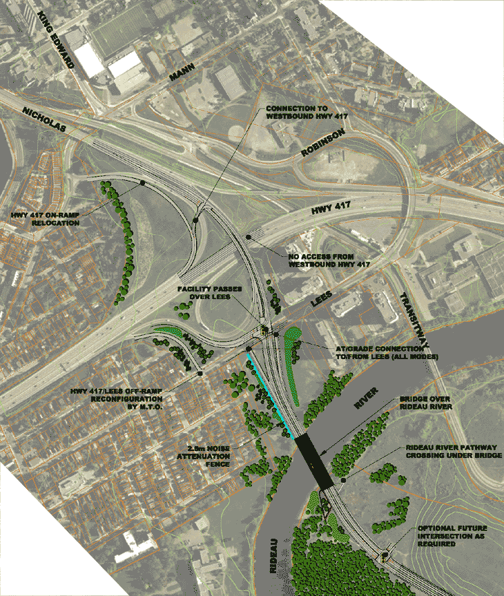
At the northern most end of the Alta Vista Corridor (AVC) the roadway would link into the Queensway (417), Nicholas and Lees.
How the interchange operates:
- traffic from the AVC road heading north will go straight through traffic lights onto Nicholas.
- traffic from the AVC road heading west will turn left and merge with traffic on the 417 on ramp.
- traffic from the AVC heading east would get off on Lees make a quick left onto the 417 onramp.
- southbound traffic from Nicholas would go straight through the traffic lights onto the AVC road.
- eastbound 417 traffic heading south would exit at Nicholas and turn right at the traffic light on the Lees overpass.
- westbound 417 traffic heading south would exit at Mann/Lees and could either circle clockwise around on Lees, or counter clockwise on Greenfield and Main to Lees to use the Lees onramp to the AVC road.